
:
Explore Tasmania’s Top 5 Walking Tracks
Tasmania is an irresistible attraction to outdoor adventurers, with its relative isolation, large tracts of unspoiled and rugged terrain, and clean, spectacular beaches just calling to be appreciated.
Helpful Hints for Trekking in Tasmania
While beautiful, Tasmania’s rugged terrain and unpredictable weather can make going for an on-foot adventure a little difficult, so it’s best to be prepared.

The breathtaking scenery and year-round physical challenges of extended hikes through rugged bushland in Tassie’s unpredictable weather are an allure that’s difficult to ignore.
The following five walks includes easy costal adventures, bushwalks into the central Tassie wilderness, and challenging multi-day walks that are not for the faint-hearted. And as with any outdoor adventure tackled in Tassie (and Australia at large), there are plenty of common-sense and often life-saving rules to be followed.
Fitness
Your fitness level and ability are perhaps the most obvious things to consider before heading off on a hike. Those with some sort of debilitating physical condition, such as recovering from an operation, should heed the advice of a medical practitioner.
If regular physical activity isn’t part of your daily life, it’s advisable not to attempt a particularly challenging walk without preparation; if you’re keen for a higher-grade hike, plan ahead and undertake a focussed, monitored exercise regime for some time in advance.
For those who are super-fit, don’t get overconfident. Remember that you need to recognise that the sometimes-fickle Tasmanian weather can change abruptly, from hot to cold and wet, and even snowy, and this can effect the conditions quickly.
Gear
You need to carry all the gear necessary to cope with any contingencies. Hiking boots are an obvious must have, as is multi-layered clothing. A properly water-proofed, good-quality hiking tent is helpful in any season.
No matter the time of year, having a fully charged torch will be a lifesaver when setting up camp at night. And pack some waterproof matches for good measure, as they can be very handy for longer, multi-day hikes.
A quality first-aid kit, basic medication, a good hat or beanie, sunglasses, mosquito repellent, camera and a good water bottle seem obvious considerations, but should be added to the pre-walk checklist. Because sometimes the most obvious thing is the most easily forgotten!
The food and water you’ll need to carry are obviously major considerations, particularly water, and should be pre-planned to provide nutrition beyond the time you expect to spend on the hike.
Even if you know you’ll be out of reliable phone reception, make sure you pack your phone and extra batteries or battery packs.
An emergency locating beacon or satellite phone can be purchased or hired and could prove lifesaving if the worst happens. Outlets for the hire or purchase of an ELB or sat phone can be found via the National Parks website.
A National Parks Pass, available online is required for entry into all Tasmanian National Parks.
Walking Track Grading
There is a simple grading system for walking tracks in Australia, indicating the difficulty of a walk with regards to experience required, gradient, path quality, signage and navigational ability.
Grade 1: Suitable for those with no bushwalking experience. Tracks will be flat and even, and under 5km in length. This grade is suitable for wheelchair users who have someone to assist them.
Grade 2: Suitable for those with no bushwalking experience. Tracks will have compacted surfaces, mellow gradients and will be no longer than 10km long.
Grade 3: Some bushwalking experience required but suited to most ages and fitness levels. Tracks may have rough surfaces and short steep sections. They may be as long as 20km.
Grade 4: Experience strongly recommended. Tracks can be long, steep, rough and a lack of directional markers may make navigation difficult.
Grade 5: Only for very experienced bushwalkers with skills in navigation and emergency first aid. Tracks can be very long, very steep and unmarked. These tracks may also include exposed sections and scrambling.
Walking Track 1: Bay of Fires Walk
The Bay of Fires Walk is considered one of Tassie’s most picturesque, with views that change by the hour as the sun sweeps over the coast.

Bay of Fires Conservation Area (Credit: Pete Harmsen)
The Bay of Fires region is a popular destination for day-trippers and enthusiastic walkers who are catered for by several guided tour operators offering a range of experiences, from easy coastal walks to guided multi-day hikes that vary in distances covered and the degree of luxury offered.
When it comes to the latter, the more expensive options can involve overnight glamping or accommodation in beach houses or lighthouse-keeper cottages, while the former can include less-exotic individual hikes utilising the basic campsites that are provided along the way. The duration of the guided walks varies, but four days is at the top end of the scale.
The Bay of Fires region was named by English Captain Tobias Furneaux in the 1770s after the sighting of Aboriginal fires along the coast that lit up the sky at night – stretches 50km along Tasmania’s north-east coast via larapuna/Eddystone Point in the Mount William National Park to Binalong Bay, not far from the picturesque fishing town of St Helens. Shell and bone-dumping grounds from cooking fires, known as middens, are still evident in some places.
The attractions of walking the Bay of Fires are consistent with the location: sandy white beaches, brilliant blue sea, orange lichen-covered granite rocks, lagoons and rocky bluffs, all against a thick low-lying coastal vegetation that is so representative of the region.

Bay of Fires (Credit: Tourism Tasmania, Andrew McIntosh)
The vistas from the Binalong Bay viewing platform or the headland at The Gardens – named after the tracts of wildflowers that grow in the area – are breathtaking, so be sure not to forget your camera!
Along with water activities, such as snorkelling and whale and dolphin spotting, there’s also abundant bird life, as well as signs of the aboriginal activity that gave this area of the Tasmanian coast its name.
A typical four-day catered walk at the Bay of Fires will begin at Boulder Point near the low-lying Mount William in the north, then work its way south to finish near the fishing village of Anson’s Bay in the south, traversing rocky gullies and exploring small, secluded beaches along the way – including the signature Binalong Bay.
The distances covered can vary enormously and walking is generally not difficult because of the flatness of the terrain. That said, you may encounter areas of soft sand. But believe us, the rewards vastly outweigh the physical effort outlaid.
Bay of Fires Walk details:
Grade: 3
Days to complete: 4
Distance: Up to 50km
Requirements: Bookings recommended/optional
Walking Track 2: Overland Walk
A challenging route and a true bucket-list trek for any avid bushwalker, the Overland Track is famous worldwide.
Not one for the faint-hearted, Tasmania’s lauded Overland Track is a six-day, 65km north-to-south adventure described by Tasmania’s Parks and Wildlife Service as a ‘serious undertaking’.
It is the predominately tackled by experienced, independent walkers, and starts at Tasmania’s iconic Cradle Mountain and finishes at Lake Saint Clair near Derwent Bridge north-west of Hobart, offering a choice between public huts with limited capacities and camping on designated tent platforms.

Overland Track, Barn Bluff, Cradle Mountain-Lake St Clair National Park (Credit: Emilie Ristevski)
It’s not recommended for kids under eight years of age. And any prospective hikers younger than 17 must be accompanied by an adult. All walkers must be thoroughly equipped, fit and experienced. A valid parks pass is required. It costs $200 for adults and $160 for children or concession card holders.
Registration for the track is at the start: From Ronny Creek on Cradle Mountain, walkers plunge into a stunning, once-in-lifetime experience that takes in glacially-carved valleys, ancient rainforests, golden button-grass moorlands and mystical alpine meadows before finishing at Australia’s deepest lake, Lake Saint Clair in Tasmania’s Wilderness World Heritage Area.
Detours can be made enroute to spectacular waterfalls and destinations such as Tasmania’s highest peak, Mount Ossa, which is 1617m above sea level.
The majority of those who complete the trek finish up at Narcissus Hut at the head of Lake Saint Clair, then make their way, either by a privately-run ferry or walking 17.5km through rainforest, to the visitor centre at the other end. Guided walks of the Overland Track are also offered by various private organisations, some complete with catering.
Peak season runs from October 1 to May 31. While the Overland Track can be undertaken in winter, it is only recommended for the very experienced. For more information about the track head over to the Tasmania Parks and Wildlife Service website, where there will also be information on how to register or contact the Parks and Wildlife Administrator.
Overland Walk details:
Grade: 4
Days to complete: 6
Distance: 65km one way
Requirements: Registration and a valid pass from parks and Wildlife service
Walking Track 3: Maria Island Walk
This charming island conceals a bloody past that is now being reclaimed by nature, providing a peaceful setting for hikers and cyclists alike. And if the idea of spending four days exploring a charming island off the east coast of Tasmania is calling your sense of adventure, then the Maria Island Walk ticks all the right boxes.
Covering approximately 115sq km, Maria Island is a World Heritage-listed National Park in a spectacular location that, though only four kilometres from Tassie’s eastern coast, feels far removed from civilisation. The island is around 20km long, from its east to west extremities, about 13km wide. There’s next to no traffic, and no permanent inhabitants on the island, apart from a few park rangers.

Maria Island (Credit: JABProduction)
It’s an idyllic place for trekkers, and offers a fully catered four-day, multi award-winning Maria Island Walk (three-day walks are also available) for just 10 people, with two guides. The walks actually start at the coastal town of Triabunna, located off the Tasman Highway, where a ferry crosses to Shoal Bay on the narrow isthmus connecting the north and south of the island.
The next four days, all topped off by candlelit gourmet dining at night, see the island’s charms revealed. From pristine beaches such as Haunted Bay in the south, to tall eucalypt forests to the peaks of Mount Maria and Bishop and Clerk in the north, where the walking tracks traverse rare cloud rainforest country on the way to views that are modestly described as simply breathtaking.
On the northern tip of the island there’s a variety of spectacular woodlands and the 300-million-year-old fossils of clams, sea fans, corals, scallop shells and sea lilies at the foot of Fossil Cliffs.
Rare, endemic birds and other wildlife inhabit the island, including Tasmanian Pademelons wallabies, wombats and an ‘insurance population’ of Tasmanian Devils introduced in 2012 to isolate the breed from a crippling facial tumour disease.
Maria Island’s history includes Aboriginal occupation from the distant past, use by sealers and whalers in the 1800s and even a relatively brief rise in population into the hundreds with the establishment of a cement factory and several hotels that existed through to the 1930s. The southern part of the island was also farmed until the late 1960s.
Maria Island is a destination not just to walkers, but also to cyclists who can explore the traffic-free roads or tackle the more challenging bush circuits.
Maria Island Walk details:
Grade: 3
Days to complete: 3-4
Distance: 42km (long option)
Requirements: Bookings recommended/optional
Walking Track 4: Three Capes Walk
The Three Capes Walk is revered as Tassie’s premier coastal bushwalking track, and takes in the beauty of the Tasman peninsula, and dips into the region’s convict past.
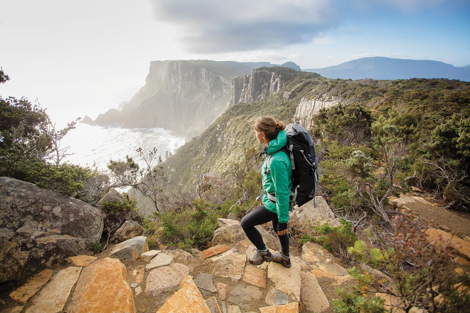
Tassie’s Three Capes Track walk is a four-day, three-night feast of stunning scenery and stimulating experiences in the Tasman National Park. Each of the three nights is spent in an architecturally designed and environmentally sensitive cabin, complete with basic cooking facilities.
The walk is organised by Tasmania’s Parks and Wildlife Services, and is designed for a range of ages and bushwalking capabilities. It offers a broad range of experiences, allowing trekkers to appreciate everything from coastal caves and ancient cliffs to lush, open valleys and sweeping mountain views.
The track begins at historic Port Arthur with a 75-minute eco-cruise that visits caves and ancient cliffs before arriving at Denmans Cove where a two-hour walk to Surveyors Cabin embraces eucalypt woodland and coastal heath, plus superb views to Cape Raoul in the south-west.
Day two is an 11km hike that traverses through heath and moorlands on the way to a short climb to Arthurs Peak where there are magnificent ocean vistas across Crescent Bay. The track then descends to the broad, windswept Ellarwey Valley and into the forest before arriving at Munro Bight.
The third day covers a longer 19km stretch, heading south-east via plunging sea cliffs to The Blade at Cape Pillar then returning via Munro for an overnight stay at Retakunna Cabin.
Day four climbs Mount Fortescue on the way to the tip of Cape Hauy. The descent to Fortescue Bay offers the chance of a dip in the ocean before returning by bus to Port Arthur.

The Three Capes Track (Credit: Tasmania Parks and Wildlife Services)
As with any outdoor adventure in Tasmania, participants in the Three Capes Track walk need an appropriate level of fitness and to be prepared for any weather contingencies. Average daytime temperatures vary from between 16 and 19 degrees in the summer and 10 and 12 degrees in the winter.
The track must be booked in advance via the Parks and Wildlife service.
Three Capes Walk details:
Grade: 3
Days to complete: 4
Distance: 48km
Requirements: Registration and a valid pass from Parks and Wildlife Services
Walking Track 5: Walls of Jerusalem Walk
If time is on your side, set aside three or four days to explore this wonderful hike that offers views that simply cannot be enjoyed by any other means.

The Walls of Jerusalem National Park (Credit: O_M St John Photography)
Located in what is known as the Land of a Thousand Lakes, the Walls of Jerusalem National Park is at the top of Tasmania, about 100km from Launceston and virtually due south of the Trans-Tasman ferry terminal in the north-coast town of Devonport.
Set within the central highlands in a region of heartbreakingly natural beauty comprising ancient Pencil Pine forests, alpine lakes, wildflowers, spectacular dolerite peaks and abundant Tasmanian wildlife, the Walls of Jerusalem National Park presents trekkers with breathtaking views that are enhanced by a unique sense of being well removed from civilisation.
The region gets its name from the rocky peaks that recall the city walls of Jerusalem – a resemblance reflected in the biblical names given to some of the region’s features: Damascus and Herod’s Gates, the network of small lakes named as Solomon’s Jewels and the Pool of Bethesda. Overlooking it all is King David’s Peak which, at 1499m, provides expansive views to be savoured by bushwalkers.
Reputed to be one of Tasmania’s best walks, the Walls of Jerusalem Walking Track can vary from moderate or challenging and can cover – depending on levels of fitness and endurance – from three to four days of trekking.

The Walls of Jerusalem National Park (Credit: O_M St John Photography)
Wild Dog Creek campsite, which is a steep 3km climb from the carpark, offers camping platforms, toilets and running water, and is the most common starting point. It is recommended to undertake the trek in spring or autumn when the weather is milder and the scenery most colourful.
The trek requires a decent amount of fitness and experience. Some of the tracks are clearly defined, where others are rudimentary, with the allocated camping areas not providing any facilities. Directional signage can also be limited and, for the safety of trekkers and the preservation the Tasmania’s spectacular environment, camping outside designated areas isn’t allowed. All trekkers must register beforehand.
Walls of Jerusalem Walk details:
Grade: 4
Days to complete: 3-4
Distance: 23km for circuit (not including Mount Jerusalem)
Requirements: Registration and a valid pass from Parks and Wildlife Service
Next steps
At Hema Maps, we strive to provide the most comprehensive and accurate maps and guides for outdoor enthusiasts looking to explore Australia's natural wonders.
Did you find this information useful? If so, please share it with your fellow explorers. Whether it's by sms, social media, or email, your friends and fellow adventurers will appreciate the valuable tips and insights we've shared.
Let's work together to make the most of every adventure.


0 comments