
:
Top 5 4WD Tracks in Cape York
Venturing up to Cape York is a journey you’ll find on almost every four-wheel-drivers adventure-filled bucket list. This remote location offers breathtaking natural landscapes and plenty of challenging 4WD-only routes. There’s a lot to see and do in this isolated peninsula, so Hema Maps has narrowed down its top five favourite tracks to help you plan your next offroad adventure.
But before you head out, some handy items to have on board are Hema Maps’ Cape York Map and Cape York Atlas & Guide.
Or, if you want to be ready for the ultimate Cape York trip – the Cape York Adventure Pack includes the Cape York Map, Cape York Atlas & Guide and the Queensland State Map in one convenient bundle.
1. CREB Track
When it comes to challenging 4WD routes, the CREB (Cairns Regional Electricity Board) track is among the toughest Australia has to offer. The route extends just over 60km and can be done as a daytrip, or overnight if you want to take it slowly. The route is graded 4WD-only and Extreme – so plan accordingly.

Hidden by deep rainforest, the CREB Track’s red-clay surface and very steep angles mean that the slightest rainfall, even days old, can render the track nearly impassable. Always check with locals for the latest information before attempting the track, and if the track has been closed by the Council, don’t drive on the track.
The best time of year is between May and October, in the dry season. Don’t attempt the track after any rain, as even a light shower can make going downhill an exercise in careful braking and steering. Even mud tyres have a hard time with the clay surface. When the CREB was the only route up the coast, everyone would use chains on their tyres to help things along. But these days the Douglas Shire Council closes the track for much of the year to deter attempts during dangerous periods and warns that if you travel on a closed road, you’ll have to pay for your own rescue.
Towing a van up CREB track isn’t advised by the council, but if you’re a careful driver with an offroad van and attempt the trip on a very dry day, you’ll be able to get through unscathed – although not unnerved.
Plan your trip carefully (this is when the Cape York map and Atlas & Guide can come in handy), because while you might see the 60km distance and think it’ll be a two- or three-hour trip, in reality it can be a much longer journey if the conditions aren’t in your favour. And as a World Heritage listed area, its especially important that all travellers respect the land and stay on the track.
Heading off from Cooktown, the Mulligan Highway heads south until you get to the Helenvale turn, which will then lead you past the renowned Lions Den Hotel (stop in for a meal or drink if you’ve got the time). Continuing on, in about 33km you’ll arrive at Ayton. From this point you can either venture down the CREB Track, or the Bloomfield Track if the CREB is closed.
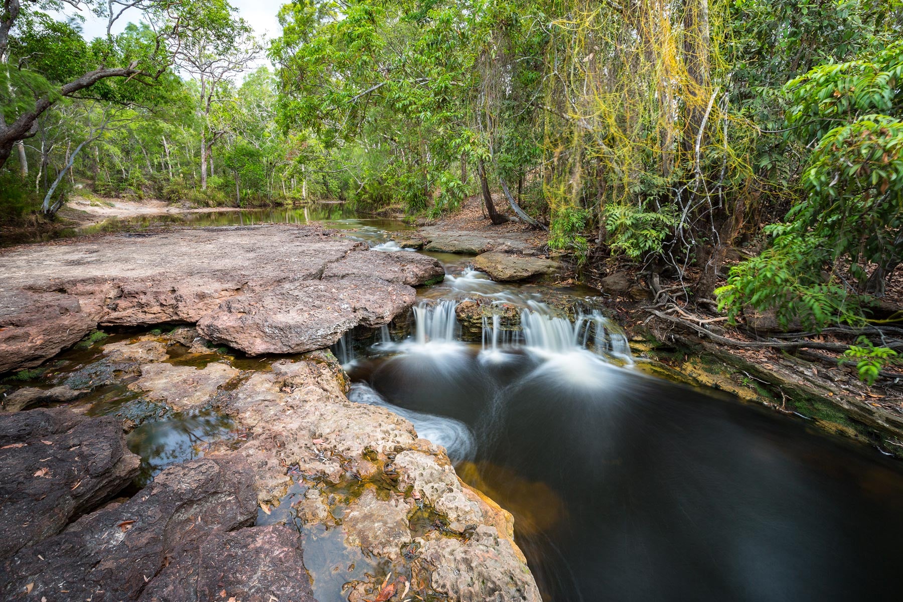
The first 15km leg of the CREB is relatively simple. Enjoy the winding gravel road that leads you through the lush rainforest and keep an eye out for waterfalls and other stunning views.

The fun (depending on how you see it) kicks in as you travel into the heart of the McDonnel Range, and this is where you need to take care on the descents. The challenges continue until you drop out of the range to the Daintree River, which is a broad shallow crossing, and arrive in the sleepy town of Daintree.
Bloomfield Track
If the CREB Track is closed, the Bloomfield Track is your next option. While not as challenging as the CREB, the Bloomfield Track still has plenty of adventures to offer, cutting through the same coastal rainforest as the CREB, crossing numerous crossings and scaling some impossibly steep hills.
The Bloomfield Track runs from Cape Tribulation in the south the Wujal Wujal in the north, is 4WD-only but it’s much more forgiving than the CREB and features concrete on the steepest sections and graded gravel the rest of the way. The track is subject to seasonal flooding, slips, loss of traction, potholes and fallen trees.
Facilities are available as far north as Cape Tribulation, and there is no camping along the Bloomfield Track.
Things to do
The CREB Track isn’t an experience you want to rush through – from the adrenaline-inspiring driving to the stunning natural surrounds, you’ll want to slow down and smell the flowers.
If you’re a waterfall lover, explore Bloomfield Falls and Roaring Meg Falls. The top of Roaring Meg Falls is a recognised women’s site for the Buru people, so signage requests men to not visit the site. There is no alcohol permitted in the Roaring Meg Falls area, and do not camp at the swimming area or beside the river’s edge.
No alcohol is permitted in the Roaring Meg Falls area. Camping is only permitted in the designated zone; do not camp at the swimming area (beach) or beside the river’s edge. Alcohol restrictions also apply in Wujal Wujal.
Heading 35km down the track from Roaring meg Falls, the lookout affords a stunning view out over the Thornton Range. Or head to Daintree and enjoy one of the several river cruises that depart from the town.

If you’re looking to camp on the CREB Track itself, there are only two places where you can do so legally. One is at Roaring Meg Falls, and the other is the Yindilli Camping Area, which you’ll find halfway along the track on the northern side.
Permits
Visitors are asked to contact a representative of the Burungu Aboriginal Corporation (traditional owners) prior to accessing Roaring Meg Falls. Fees apply for camping.
Contacts:
- Douglas Shire Council
- Burungu Aboriginal Corporation (P: (07) 4098 6248)
2. Starcke Coast
The Starcke Coast track is graded as difficult, and you should allow between two to four days to complete it. There are long stretches without anywhere to restock water, supplies or fuel, so plan accordingly.
Departing from Cooktown, the road out to Hope Vale Aboriginal community is a mix of dirt and tar, with a bitumen section on the way to Eddie’s Camp at Elim Beach. As you journey along the track, you’ll pass through white silica dunes, tropical savannah and mud flats. Continuing on from Eddie’s Camp, if you don’t mind pinstriping your vehicle you can venture onto the much rougher and sandy track with encroaching vegetation that leads all the way out to the northern side of Cape Bedford. The sand gets very soft in parts of the track, so make sure you lower your tyre pressures and utilise all your safe sand-driving techniques. But while the going might get tough, the views are certainly worth it once you reach the Cape.

On the return journey, head past Hope Vale and turn onto Endeavour Battlecamp Road towards Rinyirru (Lakefield) National Park. Around 8km later, turn onto Isabella McIvor Road. This road will turn you northwards and lead you through Elderslie, Glenrock and Starcke stations. The track tends to be in good condition, with causeways over the deep creeks and a few rough dips.
The track passes through rainforests and thick jungle, and just before you reach the Starcke homestead there is a signposted track that turns off to the right which heads eastwards towards Morgans Landing. This track has both dirt and sand sections and some creek crossings – one of which, even late in the season, gets to bonnet height. After crossing white silica sand dunes you’ll drop down onto the soft sand beach at Morgans Landing. The Morgans River mouth is to the south, and looking northwards is the beach run up to Cape Flattery. This should not be attempted near high tide.
Retrace your tyre-tracks to get back to the Starcke homestead and continue your journey north (you might need a good run up to get off the beach). This area of northern Queensland alternates between tropical savannah and tea-tree woodlands, so take it slow and enjoy the beautiful surroundings. A track runs north to the coast for about 3km before reaching the Starcke River crossing out to the mouth of the river. Here you’ll find a good camping area as well as a boat ramp if you’ve got a tinnie handy.
From this point you can continue your journey northwards to Cape Melville, or head back down to Mount Webb Wakooka Road and retrace your steps back to Cooktown.
Cape Flattery
Named by James Cook, Cape Flattery is part of the traditional area of the Guugu Yimithirr Aboriginal people and much of the original lease has been handed back.
Once you’re on the beach at Morgans Landing, it’s another 20km journey north to where you need to turn off, just before reaching the headland to Cape Flattery.
There are a number of small creeks that flood out across the beach just south of the headland, so take it slow and steady. At low tide this track is an easy run. Once you exit the beach south of the loading jetty you enter a mining area, so it’s very important to stick to the signposted track. It’s less than 5km to the beach and camping area. Small tinnies can be launched off the beach near the loading jetty, or in the protected waters on the western side of the Cape.

Anglers can enjoy some prime fishing time off the rocks, with trevally, queenfish, cod and coral trout commonly caught in the area. Or fish off the beach to try and catch flathead, threadfin salmon and whiting.
The best campsites are located on the protected north-west side of the Cape on Connie Beach. Contact the traditional owners for permission to camp here (P: 0458 554 951).
There are no facilities at Cape Flattery and the mine office is only to be access in an emergency.
Things to do
If you’re looking for a great spot to set up camp on Cape Bedford, then Thiithaarr-warra elder Eddie Deemal’s camp at Elim Beach is a great option. Enjoy views out over the cape, the towering paperbark trees that grow right up to the high-tide mark. There’s plenty of shade and amenities, including flush toilets and showers. And don’t forget to pack your camera, because the coloured sands are picture-perfect and even more colourful than those found at Rainbow Beach further south. The fishing is also legendary.

Isabella Falls on Endeavour Battlecamp Road is well worth a stop, and if you’re after another fishing location then McIvor River near Morgans Landing is a great place to stop and try your hand at catching barra, mangrove jack, tarpon, golden snapper and more.
Please note, when camping anywhere near the water, it’s important to set up camp well above the highwater mark to avoid crocodiles and keep campsites on the sand to avoid damaging beach-front vegetation.
Permits
Stop at the Hope Vale Service station for both a map and a permit to access Elim Beach.
Contacts:
3. Old Telegraph Track – South
The Old Telegraph Track (OTT) is another of the Cape’s most popular 4WD tracks, and while it’s possible to do it from north to south, it’s not advised as you’ll be going against the traffic and there are few passing opportunities.
Beginning at Bramwell Roadhouse, the start of the OTT is marked only by a small wooden sign. The track is graded as difficult, and you should allow approximately two days to complete it. The conditions of the track are as changeable as the seasons – with everything from traffic, storms, fire and the time of the year impacting it. But the best time of year to visit is between June and October, during the dry season.
Heading out from Bramwell Junction you’ll enjoy an easy few kilometres before reaching the first hurdle at Palm Creek where a steep clay descent into the creek is a chute that can very easily cause panel damage, so take it carefully.

There’s no rest for the wicked, and Dulcie Creek follows Palm Creek almost immediately. This moderately deep crossing requires you to hug the left bank before hooking back to hit the exit track.
Fording North Alice Creek is a smoother journey, and the track between this creek and the Dulhunty River won’t throw too many curveballs, although there might be the occasional washout.
Enjoy your first night of camping at Dulhunty River, with its excellent riverside campsite and shallow falls perfect for swimming. There’s a rough track out to the old water gauging station, but if you brave it, you’ll find a quiet, removed campsite away from the masses.
On day two, you’ll need to brave Bertie Creek, which requires a run up one side of the creek, then quick dogleg out to the exit to avoid some deep holes in the creek’s rocky base. Continuing along the track, there’s a turn-off to the east where you can access the Heathlands Resource Reserve and a bypass of Gunshot Creek.
Gunshot Creek once had ‘chicken tracks’, but now all the crossing’s access tracks are almost vertical. Severe vehicle damage is quite possible. Depending on when you make the attempt, you might have a line of spectators watching you make the attempt. If you have any doubts, it’s best to take the Gunshot bypass track.
Cockatoo Creek is the next one you’ll cross on your northwards journey. If you’re attempting the track early in the season, before the water levels have dropped, the entry and exit can be dangerous. But generally, it’s a straightforward crossing. The creek bottom is rocky and moderately deep, so it’s advised to walk across first to find a safe route that avoids deep holes. If you’re ready for a cooldown, this is a great place to stop for a swim or set up camp on either side of the river.

After crossing Sailor Creek, the OTT runs on the Bamaga Road for several kilometres before a turn-off on the right, where the road forks off for access to Fruit Bat Falls. Enjoy swimming in this day-use only area. The Old Telegraph Track – North, which we’ll dive into next, offers a continuation of this route.
Things to do
With a lot of adrenalin inspiring creek crossings, you might not be looking for too much more excitement on this route. But depending on how you fare, stopping at Palm Creek and Gunshot to join the spectators can always be a fun time.
Dulhunty River is a great spot for swimming under the small cascades. Children (big and small) can while away an afternoon on the old crossing exit, which has turned into a mud slide.
There are no saltwater crocodiles in any of the creeks along the OTT, so you can enjoy swimming in any of the waterways that are deep enough.
Check out the old lineman’s hut at Sailor Creek, which gives some insight into how the men who used to maintain the telegraph line lived. Or stop around 4km north of Gunshot Creek crossing, and on the western side of the track you can see the gravesite of WJ Brown, a linesman on the OTL who died here in 1945.
Little remains of the ruins of the McDonnell Telegraph Station, which once stood beside McDonnell River, which joins Cockatoo Creek just upstream from the crossing.
Permits
None apply
Contacts:
4. Old Telegraph Track – North
Now that we’ve covered the southern end of the track, we’ll tackle the north. As mentioned, it’s best to travel with the traffic heading south to north. This section of the OTT is also graded as difficult and 4WD-only.
Starting out from Bamaga Road, there’s a turn-off on the right to the Old Telegraph Road and this is where you’ll fork to the right to access Fruit Bat Falls, a popular day-use only swimming spot (sounding familiar?). This is where we’ll hit some new terrain.

From here the track runs straight until the turn-off for Eliot and Twin Falls just before Canal Creek. These falls are among the most popular swimming and photography spots on the OTT, and there’s also plenty of camping sites available.
Heading onwards, Canal Creek is a straightforward deep blue-water crossing with a clean, straight exit. If you need another camp option, there’s space here and even a crude shelter shed if rain threatens. North of Canal Creek, be prepared for the track to be corrugated and sandy and, depending on the conditions, the potential for chopped up and eroded ground near the creeks.
Next up is Sam Creek, an easy crossing which has some more great camping options, and just downstream popular clear-water swimming holes.
Mistake Creek poses a challenge with a steep, eroded entry, but the crossing is straightforward from the bottom. Continuing on, Cannibal Creek is a simple crossing with camping available. But Cypress Creek can be a bit more nerve-wracking, as it is crossed via a narrow, rickety, old log bridge that is in need of replacing.
Once your heart has stopped racing, it’s a long drive before you’ll reach the biggest obstacle south of the Jardine River: Noland’s Brook, or Bridge Creek. The bridge itself fell apart years ago, and with up to 1.5m of water and a soft sandy bottom, the right line across the creek can mean the difference between making it or not. The hard-right line is usually shallower with a firmer bottom.
Keep following the track north until you reach the old Jardine River ford, where you can enjoy camping in the open grassland. While the route continues another 1.5km to the Jardine River at the OTL crossing point, there is a right-hand track that heads eastward and passes through a swampy section which can be quite boggy in places, particularly early in the dry season. If you’re after some more campsite locations, then the Jardine River has some excellent ones, although you will have to head back the way you’ve come to join the Bypass Road, 24km from the Jardine ferry.
Twin Falls (Yaranjangu)
480m (return): 10min, Grade 2 (easy)
Things to do
Fruit Bat Falls is a fan-favourite for many who travel the OTT, whether it’s the southern or northern side of the track. It’s a day-use only site, so you’ll have to find somewhere else to camp. But it makes for a great spot to stop for lunch, despite being somewhat crowded. And of course, the falls themselves offer a beautiful swimming destination.
The nearby Eliot and Twin Falls are just as popular, offering both swimming and camping options. And you’ll soon understand why it is one of the most popular campsites on the whole OTT.
On the southern side of Canal Creek, there’s an old lineman’s hut you can have a sticky beak at.
Permits
You’ll need an e-permit for camping at the Jardine River South and Eliot Falls sites. These can be purchased online or you can get one in person at a self-service kiosk or over-the-counter booking office.
Contacts:
5. The Tip – East Coast
A bucket list destination if there ever was one, heading up to The Tip of Cape York is a stunning journey. Graded as difficult, you should allow two days – minimum – for this 4WD only track. The best time of year to visit is from May to October. Please note, alcohol restrictions apply to the entire Northern Peninsula Area. More information can be found here. And always be croc-wise when visiting The Tip – the estuaries and beaches are home to plenty of crocodiles.

Leaving from Seisia there is a backtrack which crosses through nearby rainforest and savannah before exiting south of the Croc Tent at Lockerbie.
Approximately 11km south of The Tip, there is a track that turns off towards the east and continues out to the old Somerset ruins where you’ll find a basic campsite. If you’ve got any history buffs onboard, they’ll want some time to explore the area.
Approaching Somerset ruins by the direct route, the access track ends in a dusty carpark and a flagpole which mark the original front entrance of the old settlement. Just before you enter the carpark there is a steep, rutted track leading down the hill towards the beautiful Somerset Beach, which is a popular camping area. To the left you can see the graves of Frank and Sana Jardine and various family members, and to the right, hiding behind the mangroves is the well that was once the main water supply of Somerset. In the middle of the beach, you can spot some old wooden stumps, which are all that remain of the slipway.
Whether you’re just passing through or setting up camp for a night or two, you’ll enjoy the beautiful views across Albany Passage to where rainforest-clad slopes fall into the water. And on the northern headland, which is only accessible at low tide, you can discover a cave that has its own small beach, and its walls and roof are decorated by a small collection of Aboriginal art.

Heading south along the coastline there is a roughly signposted track that heads out to Nanthau Beach via Fly Point and Vallack Point. This stretch of coastline is truly breathtaking, featuring rolling hills, sandy beaches and ruddy headlines – and is arguably the best scenic spot on the Cape.
Things to do
The Tip is overflowing with rich historical and cultural sites, beautiful landscapes, and various travellers – but the one thing it is missing is facilities – so it’s best to be self-sufficient.
The Somerset ruins are just one part of the region’s history, but it is quite neglected and what remains is slowly being reclaimed by the bush. It’s a little hard to picture what the settlement was once like, but the surrounding landscape and views make it easy to see why the location was chosen. The graves of Frank Jardine and his wife, Polynesian princess Sana Solia, can be found resting along the beach at Somerset, the surrounding trees offering plenty of shade.
And don’t forget to see the sandstone cave to the north of the homestead (only accessible at low tide), which houses Aboriginal paintings that tell a much longer historical narrative. This is the only known Aboriginal gallery north of the Quinkan sites around Laura.
Set up camp at Somerset, with views over to Albany Island, a toilet block (a rare commodity on The Tip) and shelter. If you’ve got a tinnie onboard, you can launch it into the calm Albany Passage, but don’t head too far out as the tides over the surrounding reefs can be dangerous.
If you’re interested in beachcombing or just getting away from all the other travellers, the beach-run out at Nanthau is well worth the trip. And don’t forget your fishing gear as you might have some luck catching queenfish, trevally and salmon.
Heading inland from Nanthau Headland you can explore the several perched freshwater lakes – two of which are within a fairly easy walk from the track. Lake Bronto and Lake Wicheura are both similar in size and can be found on opposite sides of the track within 3km of one another. You can easily access Lake Wicheura via the vehicle track that exits the main route. Whether you’re walking or driving, take your time and enjoy passing through the rich heath-type vegetation that is broken up by larger trees. The closer you get to the lakes and other more permanent water sources, keep an eye out for signs of pigs.
The lakes themselves are bordered by reeds, but there are small sandy beaches to discover. But no matter how enticing the water looks – don’t go swimming. Large crocodiles reportedly live in these small, isolated lakes.

Permits
The permit required to visit the Northern Peninsula Area comes with the cost of the return ferry trip across the Jardine.
Camping fees apply at the private campgrounds.
Contacts:
Next steps
At Hema Maps, we strive to provide the most comprehensive and accurate maps and guides for outdoor enthusiasts looking to explore Australia's natural wonders.
Did you find this information useful? If so, please share it with your fellow explorers. Whether it's by sms, social media, or email, your friends and fellow adventurers will appreciate the valuable tips and insights we've shared.
Let's work together to make the most of every adventure.
5 comments

Great to read your story and ‘Matts’ comments.
We went to the Cape in 1975 with a group from the LROC of Sydney in 5 fairly old early series Land Rovers. We had 6 children under the age of 7 (it was safe we made sure of that). No ferry over the Jardine in those days. All vehicles had to be waterproofed -(Grease and glad wrap as well as some Silastic!)
Took a few diversions on old Wartime tracks into the jungle – had to make our own diversions sometimes (No bush ‘bashing’ we were all aware of conservation..) Found the wreckages of a squadron of WW2 Aerocobras fighter planes just inland from the eastern beach.. Got to know some of the local people (really nice folk too) and shared lunch on the beach with them.
Finally came back along the CREB Road.
One of the best 4 weeks of my life. Would love to do it again (wish, wish!)
Incredibly informative ! Well done !
Noticed you didn’t include the Old Coach Road. The OCR has turned into an extreme challenge. Did it in Aug 23 and thought sections were comp truck only. It shouldn’t be attempted without twin lockers, good wheel travel, winch & a second vehicle.
These tracks up at Cape York are getting lots of traffic & are becoming more and more difficult as each vehicle cuts them up.
The entry to Palm Creek on the OTT is pretty much vertical & tougher than Gunshot now.
If you’re a local, give em a crack, but if you’ve got 1000+ kms to get home, you may like to just watch?
Buon giorno ,
siete la migliore guida per visitare l’Australia .
Senza di voi e’ impossibile .
Complimenti .
Giulio Francia